


Tour des Six: stage 4 / 7
Ostello Bellevue › Chamois › Col Pillonnet › Antagnod › Mascognaz › Vieux Crest hut
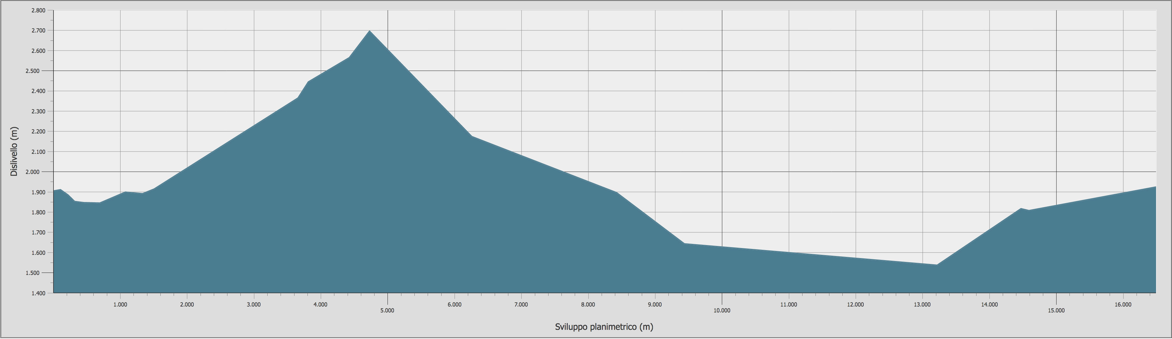
Stage duration, distance and elevation gain
| DEPARTURE | ALTITUDE | ARRIVAL | ALTITUDE | TIME | DISTANCE | POSITIVE ELEVATION GAIN | DIFFICULTY |
|---|---|---|---|---|---|---|---|
| Rifugio Ermitage | 1.927 m | Chamois | 1.823 m | 00.12 | 642 m | / | T - E |
| Chamois | 1.823 m | Col Pillonnet | 2.696 m | 02.55 | 4.726 m | 884 m | T - E |
| Col Pillonnet | 2.696 m | Antagnod | 1.682 m | 01.54 | 4.769 m | / | E |
| Antagnod | 1.682 m | Champoluc | 1.545 m | 00.39 | 2.452 m | / | T - E |
| Champoluc | 1.545 m | Mascognaz | 1.809 m | 00.51 | 1.340 m | 286 m | E |
| Mascognaz | 1.809 m | Rifugio Vieux Crest | 1.925 m | 00.43 | 1.660 m | 172 m | E |
| TOTAL | 7.14 | 15.589 m | 1.342 m | E | |||
All the technical data on this site (kml and gpx tracks, chart data and topographic profile) were taken from the Autonomous Region of Valle d'Aosta Register of Footpaths.
Official website: http://geonavsct.partout.it/pub/geosentieri/
Altimetry

Area download : Tour des Six tracks for your GPS
 Download the route of the stage in gpx format [ 57,17 kb ]
Download topographic profile of stage 4/7 Tour des Six [ 194,97 kb ]
The route
- Book now
- send us an email
- tel. +39 348 52 04 316